You can follow our progress on a map on the Wayfaring.com site.
Follow Our Walk on a Map
October 15th, 2008 · No Comments
→ No CommentsTags: Uncategorized
Day 26 – Tennessee! and Some Roadside Attractions
October 15th, 2008 · No Comments
by Dwayne Phillips
Today we walked through the twin cities of Bristol, Virginia and Bristol, Tennessee. Again the weather was sunny and reached the mid-80s F. It seems that we have set record highs for temperature the last three days. It has been low humidity and comfortable. It now appears that we will dodge the rain one more time tomorrow.
Tennessee! After some 320 miles on U.S. Route 11 we reached the Virginia-Tennessee border. The border is in the middle of the two Bristols and easy to miss if you are not looking for it. I wanted a good photograph of the “Welcome to Tennessee” sign, but (1) there wasn’t much of a sign there and (2) the sun was at the worst possible angle. Alas, here is the best I could do. Quite a let down after 26 days of walking. 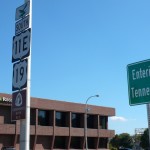
The sign also shows another oddity: U.S. Route 11 splits in Bristol, Virginia into 11E and 11W. We are following 11E until the two join again near Knoxville, Tennessee.
Walking through the Bristols was fairly boring. Route 11 has lots of close-to-the-Interstate types of things on both ends of town. For a while though, Route 11 was part of Euclid Ave in Virginia. That is a nice neighborhood of homes built in the 1930s through the 1960s. It has plenty of well kept homes and yards.
Now to the more interesting items: the roadside attractions.
This is an old car I saw stored in a mini-storage place north of the Bristols. (1) I don’t know the make, model, or year of the car. Perhaps someone out there who knows such will comment and let me know. (2) How in the world did they fit that car into that space. My guess is they lifted it straight in with a forklift or something. Still, there isn’t an inch of space on either end of the car. 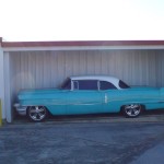
Here is yet another drive-in movie theatre – the Moonlight Theatre south of Abingdon, Virginia. This is still in operation and still showing movies on Friday, Saturday, and Sunday nights. 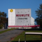
Here is a Statue of Liberty in Bristol, Virginia. This photo doesn’t give a good showing of the size or detail of this statue. It is impressive to see in person. I don’t know how it got here, but it sits next to a Liberty Income Tax service office. I saw three different Liberty Income Tax offices today, but this was the only one with such a statue. 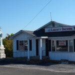
Finally, I walked up to a Starbucks Coffee shop in the northen end of Bristol, Virginia and had a good cup of Starbucks coffee. I like their coffee. I know that I have put a few comments in this blog nagging Starbucks about its prices and I still think their prices are too high. This is the only Starbucks I have see in 320 miles of U.S. Route 11. Hint, hint, hint to Starbucks – you may be missing a good market. No photos of the Starbucks as they all look the same. Just go see your local one and this one looks just like it.
→ No CommentsTags: Sullivan County · Tennessee · Virginia · Washington County
Day 25 – Historic Sites, Another Trail, and Rural Tanning
October 14th, 2008 · No Comments
by Dwayne Phillips
Today we started 15 miles north of Abingdon, Virginia and ended in Abingdon. The weather was again sunny and into the 80s F. A fine day for walking.
Most of the day we spent walking through rural areas. We walked near Glade Spring and Emory, Virginia. I write “near” because we were on Route 11 which was on one side of Interstate 81 while these towns were on the opposite side of I-81.
We did take a side trip to Emory to see Emory & Henry College (that is with an ampersand “&” in there and NOT the word “and.” That is official and they are serious about it.) This is the oldest college in Southwestern Virginia, founded 1836, so the entire place is a historic site. Absolutely beautiful. I didn’t take any photos as you really need a video of riding through the campus. This video should go in the dictionary next to the word “college.” It is what I imagine when I think of college.
I did take a photo of the Emory Post Office which is across the street from the college. I also put this photo on the Wikipedia page for Emory, Virginia. By the way, everything “in” Emory is across the street from Emory & Henry College.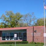
Abingdon is a historic town – the whole town is historic. Downtown is about 20 square blocks of history. The town was founded in the 1770s about the same time the country was founded. There are plenty of 1700s buildings, 1800s buildings, and even some 1900s buildings. It is all quite impressive with many shops that are real shops, not junk stores with an “Antiques” sign out front.
If you are in Southwestern Virginia and have a day or a few hours to see one place, visit Abingdon.
The most impressive building in town for me is the St Thomas Episcopal Church. It was “only” built in 1846, but an impressive building nonetheless. The Wikipedia page for Abingdon has several downtown photos, so I didn’t add any.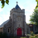
The oddity of the day was the rural tanning salons. Ten to fifteen miles north of Abingdon are a number of small businesses spread along Route 11. Maybe half a dozen of them have tanning as a sideline. There was an auto body shop that also did tanning, several beauty salons that also did tanning, a second-hand clothing store that also did tanning. I didn’t see any churches that also did tanning. Someone came through this area selling tanning beds or whatever they use and convinced people that it is a good side business. I didn’t think that people in a rural area were concerned about getting enough sun. We are getting plenty of sun while walking, so we didn’t try any of the tanning places.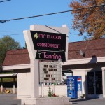
And we ran into another trail or road – The Crooked Road, Virginia’s Heritage Music Trail. This runs through southwest and southern Virginia and celebrates mountain and bluegrass music. I love it! 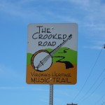 Here is yet another trail that would be great fun to walk or ride or traverse somehow.
I have to give a special mention to the Rosedale Baptist Church a few miles north of Abingdon. We sat on one of their picnic tables in the shade to eat our lunch. Three of their Pastors came out (they were having a meeting and breaking for lunch), gave us bottles of water, and chatted a while. They let us use their indoor bathrooms and were genuinely kind to us. Thank you Pastors Paxton, Stringer, and Stapleton.
→ No CommentsTags: Virginia · Washington County
Day 24 – A Visit from Friends and 50-cent Coffee
October 13th, 2008 · No Comments
by Dwayne Phillips
Today we walked through Seven Mile Ford and Chilhowie, Virginia. We covered 12 miles. The weather was clear, sunny, and reached 85 degress F.
Seven Mile Ford is a wide spot in the road. It was pretty big for this type of town with businesses and several dozen brick homes. I stopped into the store shown here for a cup of coffee. They were out, but brewed me a fresh pot quickly. 50 cents for good, fresh coffee. Is anyone at Starbucks reading this? Coffee doesn’t have to cost $1.50.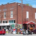
This place has fresh produce, groceries, hardware, farm parts, and serves meals as well in booths inside. Today’s special was mashed potatoes with roast beef and gravy piled on top. I had already eaten lunch.
I put this photo on the Seven Mile Ford page on Wikipedia.
Chilhowie is a bigger town with three schools, half a dozen churches, shopping centers and such. Here is a photo of the Baptist Church on Route 11. I put this photo on the Chilhowie page on Wikipedia. 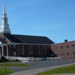
“Chilhowie” is an indian word meaning something like “valley full of deer.”
There were several historical markers in the area. In the 1750s, several people came to this place and built homes. That made this the western-most settlement in the New World at the time. Actually, the western-most English settlement as the Spanish were already in Santa Fe, New Mexico for decades, but Santa Fe is not on Route 11, so we won’t count that.
The treat of the day was when a couple of friends Jim and his wife Nadine ran into us (figuratively) in the early afternoon. They were driving from Tennessee back to Northern Virginia and knew about where we were on the road. It was fun to see them.
The humorous item was they didn’t seem to know how to leave us. In normal situations, you just don’t leave people standing on the side of the road in the middle of no where. That, however, is our chosen situation. So they left us, and we continued walking down the highway.
→ No CommentsTags: Smyth County · Virginia
Day 23 – Churches and Memorials
October 11th, 2008 · No Comments
by Dwayne Phillips
Today we walked through Atkins and Marion, Virginia. The weather was lousy again this morning. It is cool and wet so you wear a rain jacket, but it is also warm enough that you perspire heavily under the jacket. Ick. We covered 12 miles.
Atkins is a wide place in the road, but much bigger than the ones we have traversed so far. It has a Post Office, a school, 100+ house trailers, several dozen homes, and two factories. I was surprised. I put a photo of the Atkins Post Office on the Wikipedia page for Atkins.
Atkins and Marion are within five miles of one another, but are worlds apart. Marion is the 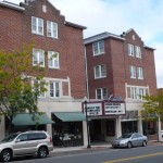 classic Main Street town. Route 11 is the Main Street. Downtown Marion is about six blocks long. It is in great shape with stores, restaurants, other businesses, and churches. Here is a photo of the Smyth County Courthouse and the Lincoln Theater.
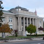
Also in Marion is the Royal Oak Presbyterian Church (shown below to the left). The building was built in 1923. The Church was formed in 1776. The same year as, well, you know.
Visit Marion if you are in far Southwestern Virginia. They have put much effort into their downtown, and it shows. I put a photo of the restored Lincoln Theatre (on Main Street) on the Wikipedia page for Marion.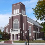
Here is another church we passed on Route 11. It is St Paul’s Lutheran Church (below and to the right). The building was finished in 1916, and the church itself was formed in 1776. What amazes me about St Paul’s is that today it is still out in the middle of no where. It is a few miles from Rural Retreat, Virginia on a side road to a side road. I find it difficult to imagine how far out in the middle of no where this spot was in 1776.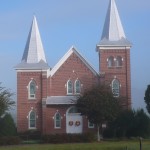
St Paul’s building is impressive, but the history is in the graveyard next to the building. There are many markers from the 1700s. There are also markers from the 1800s with a number of men who died in the Civil War. Some of those inscriptions read that they died “defending their country.”
On the grounds of the Smyth County Courthouse in Marion is a memorial built in 1906. It is for the men who died in the Civil War. It reads “To the defenders of state sovereignty.”
These memorials, built soon after the Civil War by people who were involved in it, express what the people of this region felt. The war was “The War Between the States” and it was fought over states rights. That is not the feeling of most historians of today. That is the feeling of those involved at the time. This is not a comment, just an observation.
→ No CommentsTags: Smyth County · Virginia
Day 22 – A Big Pencil, a Big Bird, and a Big Screen
October 9th, 2008 · No Comments
by Dwayne Phillips
Today we walked through Wytheville and near Rural Retreat, Virginia. The weather was lousy most of the day. Really warm, foggy, and sticky in the morning. The afternoon threatened rain. We covered about 15 miles again.
The big pencil – this is in front of an office supply store on Main Street in downtown Wytheville. I love stuff like this. It makes stores and towns look different. Funny how the golden arches look the same worldwide. Boring. 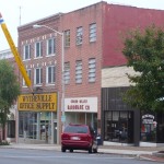
By the way, as far as I can tell, Wytheville is pronounced to rhyme with the word “with” not the word “white.” Actually, most locals call it “wee-ith” (two syllables).
I put a photo of the Wytheville courthouse on the Wikipedia page for Wytheville.
Wytheville has a good downtown area – a nice mix of 1800s and 1900s. If you are on I-81 or I-77 in the area, hop off and spend an hour there. They have several interesting local restaurants.
The big bird – this bird was standing in a pasture with some cows just off Route 11. Karen came along and took this photo. I have no idea why such a bird is in a pasture with some cows. I think it is an ostrich. Karen thinks an emu. Does anyone out there know how have a guess? 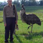 And yes, if you click on the photo and look at it closely, I am watching the bird out of the corner of my eye. I didn’t need it to reach across the fence and, well whatever these things do to people who aren’t looking.
The big screen – yet another drive in movie theater that appears to be in operation. This is the Hiland Drive In established 1952 (older than me). It is on Route 11 near Rural Retreat. What is fascinating here is that a house is built into the back side of the screen structure. Look at the photo closely and you will see the house. This is one of those “buy the house and a business at the same time.” I have never seen a design like this before. Great stuff! 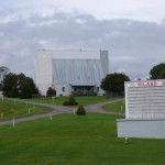
A word about Rural Retreat. Route 11 doesn’t go through it. Most of the day I-81 was 200 yards to my right as I was walking down Route 11. Rural Retreat is off a couple of miles to my left. There were several businesses and churches on Route 11 at this crossroads.
A pretty place – one final photo for the day. This is just another farm house on Route 11 south of Wytheville. A lush green pasture, a brown house, a red fence, and several trees turning fall colors. It looks better in person. I wish I were a better outdoor landscape photographer.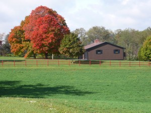
→ No CommentsTags: Smyth County · Virginia · Wythe County
Day 21 – A Double Wrong-Way Concurrency
October 8th, 2008 · No Comments
by Dwayne Phillips
Today we walked from where we left off yesterday (about five miles south of Pulaski) to the outskirts of Wytheville. We sort of passed through Fort Chiswell, Virginia. Cloudy all day with drizzle all afternoon. No heavy rain though.
All the walking was rural. Most of the time Interstate 81 was 50 feet or less to my left. It was noisy. Houses, gas stations, and other businesses tend to cluster around the Interstate exits.
Fort Chiswell is a place that doesn’t really exist. A real fort was built here in 1758 for use in the French and Indian War. The place sort of went to ruin in the 1800s and the original foundations were covered over by Interstate 77. That doesn’t seem like a nice thing to do to something with so much history, but…
Again, there is no Fort Chiswell. The people who live here in this place that isn’t here use Max Meadows, Virginia as their postal address.
Here is a photo of the Fort Chiswell Historical marker. The only way to see this marker is to be on East Lee Highway. If you are driving, you will probably miss it. That is too bad, as it is an impressive marker put here by the Daughters of the American Revolution in 1924. (The marker itself is 84 years old!) 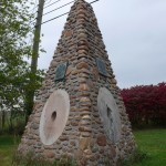
It is hard to imagine, but this Interstate highway area was once a frontier gateway. This was the edge of America for decades. The marker also commemorates the Wilderness Road. People passed through here to settle Tennessee and Kentucky.
East Lee Highway is a frontage road on the north side of I-81. I write that it is a frontage road as it is not Route 11. Route 11 is a concurrency with Interstate 81. That means it is the same road.
Please read this paragraph slowly and carefully as I try to explain a double wrong-way concurrency. U.S. Route 11 is a concurrency here with U.S. Route 52. They form a wrong-way concurrency as Route 11 is going south while Route 52 is going north. The same is true here for I-81 and I-77. They form a wrong-way concurrency as I-81 is going south and I-77 is going north. Given there are two wrong-way concurrencies all on one road, this is a double wrong-way concurrency. See, look at the photo for proof: 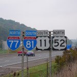
The photo also indicates how close to the interstate we walked all afternoon. I could spit and hit the cars, not that I would do that of course except for demonstration purposes.
Now, if you understand a double wrong-way concurrency, please explain to me the current house loan, credit crunch, congressional bailout that gave tax credits to wooden arrows for children situation.
Wikipedia’s explanation of the mess (the double wrong-way concurrency) is pretty good.
I put today’s two photos on the Fort Chiswell Wikipedia page. I don’t know how a place that doesn’t really exist got a Wikipedia page, but that’s the way it is sometimes.
ONE MORE THING – somehow magically we are back on U.S. Bicycle Route 76. I have no idea how that thing winds around. I suspect that someone is moving the signs to put them in our path every week or so.
→ No CommentsTags: Pulaski County · Virginia · Wythe County
Live Music at Hardee’s
October 7th, 2008 · No Comments
by Dwayne Phillips
This evening (October 7th) we ate dinner at Hardee’s near Dublin, Virginia. Something was odd when we walked in as there appeared to be a dozen people sitting but not eating. Then I saw in a far corner a couple of guitar cases and an upright bass.
We ordered our “food” (two chilli dogs for $3 – the big time) and sat to wait for it to be brought to our table. The people sitting in the place were old. Most looked in their 70s. I felt young again!
Something was up. We talked to a few people and learned that there was going to be live bluegrass music this evening. Sure enough, as time passed more (older) people filed in, ordered coffee and sat.
I hoped that we were not sitting in anyone’s favorite booth. If we were, no one said anything.
At 6PM, the music started. Three guitars (two played by ladies), an upright bass played by a 5-foot 4-inch farmer lady, two fiddles, and a banjo. The musicians and singers wandered in and sat in a circle.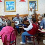
They sang and played. When one song ended, there was much talking and laughing, and the next song would slowly start on its own.
It seems that bluegrass is played here two Tuesdays a month. Gospel is played two Mondays a month. Hurray for Hardee’s.
The place was packed. Men in straw cowboy hats and “Farm Supply Store” baseball caps sat and elbowed on another while they peeled whatever with pocket knives. Women with white hair and a few with red dye hair laughed and murmured about the men with their dirty pocket knives. One of the guitar playing ladies knocked over her coffee cup and spilled coffee everywhere. One old man stood, pulled off his shirt, and showed everyone something funny printed on his blue t-shirt. Someone told us that Hardee’s didn’t allow any dancing as they were afraid someone might be hurt (broken hips, you know). Someone brought a couple of cakes or something wrapped in aluminum foil. I guess that was for later.
These people are happy. They are having fun.
It is good great to be in Real America.
→ No CommentsTags: Virginia
Day 20 – The VW Graveyard and a BIG Hill
October 7th, 2008 · No Comments
by Dwayne Phillips
Today we walked through Dublin and Pulaski, Virginia. We covered about 17 miles. The weather continues to be great.
Most of the walking today was through the country side. We started north of Dublin and a railroad track was 50 feet to my left. No trains though. I saw a large house trailer part. More than 100 trailers. These trailer parks are becoming more prevalent the past week.
Dublin is a small rural town re-growing about Route 11. There is an old Dublin that grew around “old route 11” which is parallel to and a block away from Route 11. I took a picture of the old train station there and put it on Dublin’s Wikipedia page. Dublin also has an exit from Interstate 81, so there is a separate economy two miles away with motels, restaurants, and a Wal-Mart Supercenter.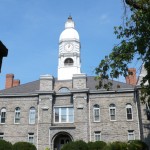
Pulaski is a much bigger town with its own suburbs and such. The noteworthy site in town is the old courthouse with its clock tower. Downtown is clean, but has few businesses there. It has some offices related to the courthouse, some charitable places, and a few political campaign offices. This doesn’t look healthy. I put a photo of Main Street on Pulaski’s Wikipedia page.
Pulaski is a city that is struggling to stop aging. There is some success in places, but age is showing poorly in many others.
The surprise in Pulaski is the VW graveyard shown here. I have no idea what this place is, but here it is. There are over 60 VW vans parked here within inches of one another. These are not the 1960s vans, but the 1970s models. Does anyone know what this is?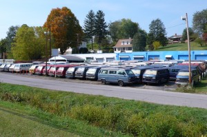
Let’s have a contest for the best caption of that photo.
While walking in Pulaski, I could see hills where Route 11 went south. I dreaded that. It was quite an experience. I checked several sources and my estimate is that I walked up an 800-foot rise. There is an overlook place at the top of the hill (not sure what the hill is called?). The Draper valley is to the south. Beautiful. I “ran” down the other side of the hill (only a 500-foot drop). Running may not be the right word. I kind of shuffled my feet with tall steps and let gravity do the rest. It was fun.
One side note for the day. For some reason the roads had banked gravel shoulders. We struggled walking on these most of the day. The result was blisters on the outside of our heels on both feet. I hope they go away during the night. Again, THERE WILL BE NO PHOTOS OF BLISTERS ON THIS BLOG – but these are beauties!
→ No CommentsTags: Pulaski County · Virginia
Day 19 – The Pink Pig Van and Other Signs of Academia
October 7th, 2008 · No Comments
by Dwayne Phillips
Today we walked through Christiansburg, Radford, and Fairlawn, Virginia. We covered 14 miles – pretty good considering we drove four hours before we started walking. The weather was fine again – 60 degrees F to 75 degrees F and the winds were calm.
We started at the I-81 exit for Christiansburg. First leg was a Golden Mile with car dealerships one after the other. Then we entered an area that was almost rural. It had lots of mobile homes and chain saw sales and repair places. Finally – downtown. Main street Christiansburg is not a historic district. It is mostly mid- to late-twentieth century buildings. It doesn’t have much character, but it is functional and attractive. Here is a photo. I also placed this photo on Christiansburg’s Wikipedia page.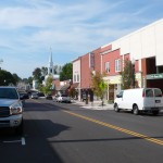
Christiansburg‘s big claim to fame – apologies to the locals – is that this is where you exit Interstate 81 to go to Blacksburg and Virginia Tech. My oldest son and his wife attended and graduated VT. We didn’t swing far enough off course to see VT, but it is still there. It is a large state university specializing in engineering and military science. Mostly it is a place where Northern Virginia kids go to get away from their parents for four years. That may only be a rumor, but I have heard it often.
Between Christiansburg and Radford is about 8 rural miles. The country is pretty, but today a construction crew was putting down new asphalt shoulders. Two things: (1) we couldn’t walk on the shoulders because that would cover our shoes with oil. (2) The construction crew didn’t know how to move traffic around their work. What a mess!
Next up is the city of Radford (1856) and Radford University. RU began as the Radford State Teachers College in 1913. It is a 20th century college and a state university. Kids who don’t want the big size of Virginia Tech, but do want to get away from home, come here. At least that is what I have heard from parents who’s kids have come here. I am sure there are other reasons. As a recent college, the architecture of the buildings is not noteworthy. The city of Radford fits into the crescent of the Pulaski New River. Route 11, which goes down one side of RU, curves into this crescent. Some of the RU buildings have a curve in them on the side adjacent to Route 11. A nice touch.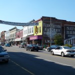
Downtown Radford is much like Christiansburg – mid-twentieth century. One note, there are three tatoo parlors on one block in downtown. I don’t know why and I don’t know how they all stay in business. Here is a photo of main street. I put this photo on Radford’s Wikipedia page. Today there was something odd about the traffic. Route 11 going north was clogged with tractor trailer rigs.
Route 11 crosses the Pulaski River as it exits Radford and enters Pulaski County. The River is 200 yards wide at this point (I stepped it off), but only a few feet deep.
On the far side of the river is Fairlawn. This is one of those wide spots in the road. It has a fast food mile. There is one franchise of every major fast food corporation in America on this mile.
Otherwise, Route 11 becomes a four-lane divided highway as it rolls through the countryside. Traffic was heavy today for some reason.
The pink pig van? Here it is. This was in front of a Bar-B-Que place in Christiansburg. It seemed not to fit at all with two neighboring towns that had big universities. I tend to notice things that don’t fit at all. Please note that I did NOT put this photo on any Wikipedia page.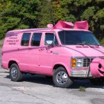
→ No CommentsTags: Montgomery County · Pulaski County · Virginia
