by Dwayne Phillips
I reached the southern terminus of U.S. Route 11.
Today’s was a 17-mile walk. The weather was fine again, a little warm, with 65 in the morning and 80 in the afternoon and few clouds in the sky.
I walked through Slidell and Irish Bayou, Louisiana as well as the Bayou Sauvage National Wildlife Refuge.
Slidell is a fairly big city with motels, businesses, several schools, and so on. It has a nice old downtown area as well as all the trappings of the Golden Mile stretching both North-South along Route 11 and East-West along Route 190 as well as Interstate 59/10 and Interstate 12.
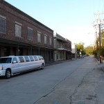
Part of Downtown Slidell
The Wikipedia page for Slidell has a few photos already. I put a photo of the train station that is in old downtown. It is a working station with Amtrak service. It also has a bar in it. Leave it to south Louisiana to have a bar in a train station. Here is a photo of one downtown street.
I enjoyed walking through Slidell – about 5 miles North to South. They have a sidewalk the entire length of the city. Some one take note of that.
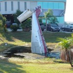
A Plane
South of Slidell you see lots of water everywhere. Most of this area was wiped clean by Hurricane Katrina, so almost everything above ground is new. Some one thought this was humorous or something to stick a plane fuselage into the mud. I like it.
Note about the landscape here – the land is as flat as water.
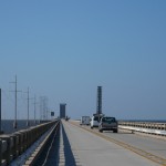
Raised Drawbridges Over Lake Ponchartrain
The next big thing is the Route 11 bridge across the narrow part of Lake Ponchartrain. This bridge is five miles long. Look at this photo of the roadway carefully. The roadway does no rise, that is a drawbridge up in the air. The large object pointing way up in the air to the right is the train drawbridge. They have to raise these for almost any boat. The train bridge is only 3 or 4 feet above the water while Route 11’s bridge is may 8 or 10 feet above the water.
I walked four of the five miles of the bridge’s length. A couple of New Orleans Police gave me a ride for the last mile. They said that walking on the bridge is not allowed. I looked high and low for signs prohibiting pedestrians. I spent a half hour last night looking on the Internet about this as well. Oh well, I got enough of the experience and the officers were courteous.

A Castle in Irish Bayou
South of Lake Ponchartrain is an area called Irish Bayou. At this point, Route 11 is about 18 inches above the surrounding water. That felt funny walking through there. All the structures are above ground in one way or another. All except this one – a castle. The curved walls and concrete construction are pretty good in a storm. It looks neat as well.
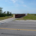
A Flood Gate
Then I entered the Wildlife Refuge. At the entrance is this flood gate on rails. It is about four feet tall. In the event of a storm surge they close it to keep the water from…well I don’t know. It doesn’t seem to make sense to me, but it is here at taxpayer’s expense.
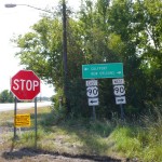
The Terminus
And then I reached the end. There isn’t much at the end of Route 11. It seems there should be a big marker, after all this Route goes from upper New York state down to here – at the end of dry land. All that is here are these signs. Sort of anti-climactic.
To mark the occasion, I wrote this note on a sign down here. I won’t say which one, but here it is. Take a trip down to the terminus and look around. It won’t be hard to find.
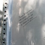
My Note
.
In the coming days, I will catch up on some other things that have happened while walking. Stay tuned for a while.
.
.
.

The Sign Said STOP, So I Did
Tags: Louisiana · Orleans Parish · St Tammany Parish
by Dwayne Phillips
Another beautiful day for a walk in the countryside – 45 in the morning and 80 in the afternoon without a cloud in the sky. And I finally crossed into Louisiana. Not much farther to go. I walked through the towns of Carriere and Ozona as well as the city of Picayune in Mississippi. In Louisiana, no towns, but I did see a sign that read “St Joe.” I walked 20 miles today – a long day of walking.
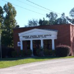
The Carriere Post Office
First up was the little town of Carriere. There is no Wikipedia page for Carriere. It has a Volunteer Fire Department, a High School, Bank, several gas stations and a Post Office (photo here). This looks like a nice place to live and have a family.
A few miles later I saw a green sign with “Ozona” on it. I never saw anything that would indicate any town or place or anything.
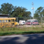
Where the Public Vehicles Go to Die
Slowly but surely, the country side picked up more and more houses and businesses. I spotted this place with several old, decaying public vehicles. Who knows why they come here to rust.
Picayune is a fine small city. The downtown is in good shape with almost every storefront occupied and all the buildings freshly painted. The Wikipedia page for Picayune has several photos already, so I didn’t put any on there. Here is an extra photo. They have a small railroad exhibit downtown near the tracks and near their train station. Their train station is a working station with Amtrak passenger service.

I walked five miles in Louisiana today. Route 11 was straight and flat. It was mostly a wooded corridor with a few businesses here and there. Tomorrow we should see much more as we go through the city of Slidell.
The trip into Louisiana was a bit disappointing. Route 11 runs concurrent with I-59 as it crosses into Louisiana. You cannot walk on the Interstate, so we drove about four miles from Mississippi to Louisiana. I couldn’t stand next to the “Welcome to Louisiana” sign. Rats.
Two highlights for tomorrow. (1) Walking across a five-mile bridge over Lake Ponchartrain. (2) Hitting the end of Route 11 and ending this walk.
Tags: Louisiana · Mississippi · Pearl River County · St Tammany Parish
by Dwayne Phillips
This was a day made for a walk in the country. It was 40 degrees in the morning and 70 in the afternoon with clear skies and no wind all day. I walked 17 miles today. Wonderful.
I walked through the towns of Poplarville, Derby, and McNeill, Mississippi.
Poplarville is a big town. It has the Pearl River Community College right on Route 11. When I was in high school (sometime in the last century), several of the guys I went to high school with came over to the Junior College (as it was called then) to play football and baseball. The Mississippi junior colleges were known for taking athletes from small high schools like I attended. I put a photo of the college on the Wikipedia page for Poplarville.

A Backyard Helicopter
I saw this helicopter in a backyard in Poplarville. It is a real helicopter, not a radio-controlled model. It holds two people and actually can take off and land in this person’s yard.
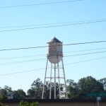
The Movie Star Water Tower
Down the highway right across from the college was this water tower. I still don’t know what Movie Star is. The water tower was next to a factory of some sort. There weren’t any cars at the factory, so I really don’t know if it is open. One of my theories about Movie Star is that it is a small lingerie company. I don’t know. They do have a neat water tower.
Oh, in Poplarville I bought a cup of good Community Coffee for 25 cents. That is twenty-five cents folks. Is anyone out there reading this who knows someone at Starbucks. 25 cents 25 cents 25 cents. Someone pass this along to Starbucks. Did I mention that the cup of coffee cost 25 cents?
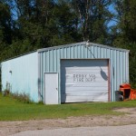
The Derby, Mississippi Volunteer Fire Department
Derby is a narrow spot in the road. There weren’t any signs saying I was in Derby, but I saw a couple of places that had the name Derby on them like this Volunteer Fire Department. I don’t know if there is anything in this garage.
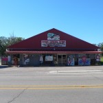
The McNeill General Store
Next was the town of McNeill. It is a wide spot in the road with houses, a few stores, and a post office. Here is a fine looking general store and the post office. There is no Wikipedia page for McNeill. What a shame.
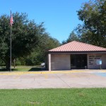
The McNeill, Mississippi Post Office
And then there was this sign. This is the first sign I have seen on Route 11 mentioning New Orleans. The sign says 73 miles to New Orleans. My calculations are that the end of Route 11 is 45 miles from this sign.
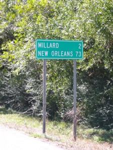
The First New Orleans Sign I have Seen
Tags: Uncategorized
be Dwayne Phillips
Fall weather remained with us today. Ahh, I have been waiting four weeks for this weather. Sunny all day, 48 to 63 degrees, and cool north wind. Wonderful.
I walked 20 miles today. That is a little farther than needed, but tomorrow is a day of rest, so I pushed it. I walked through the big towns of Purvis and Lumberton, Mississippi. Really, these two are big towns.
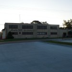
The Movie Star Restaurant
Purvis has shopping centers, banks, restaurants, and all. I couldn’t see downtown from Route 11. I could see this restaurant. Someone told me that “Movie Star” was a bottling company or something. Someone turned the old factory building in to a restaurant. The sign on the other side of the building said something like, “still ugly on the outside, tastes good on the inside.” The building really is ugly on the outside.
I didn’t post any photos of Purvis. The Wikipedia page for Purvis is excellent. Someone has done a lot of work on it. See it, there are half a dozen good photographs.

The Lumberton Post Office
Lumberton is another pretty big town. It spreads east to west, so a north to south walk is quick. Its main street branches off Route 11. It doesn’t look good. Most of the store fronts are vacant. Here is a photo of the Lumberton Post Office.
If anyone out there works for the postal service, take a good look. This is what a small town post office should look like. Not like all the others.
Now for the name of the town – Lumberton. No doubt this was once called Lumber Town. That summarizes most of the economy between Tuscaloosa, Alabama and the Gulf Coast. This area is solid with pine trees and logging trucks. The trees become lumber and paper. They are called tree farms; they seem to work, but I’m an engineer not a biologists or any of those other sciences that debate about managed forestry.
Today, oil and natural gas have augmented the economy of the area. The work is hard and dirty, but it is work and these are jobs.
Several things about the walk today.
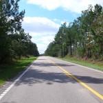
The Wooded Corridor
(1) It seemed boring. I call this the “wooded corridor.” See this photo. The road is lined thick with trees making a corridor of woods. There isn’t much to see. Openings in the woods are for a few side roads and houses.
(2) The houses were widely separated, but high quality. It seemed strange, but the vast majority of the homes on the side of the road looked good. Most were brick homes that were well maintained. There was little trash and clutter. It all seemed out of place for some reason. It was a good surprise.
(3) I lost my little golf pencil – the one that I write in my pocket notebook. I was pretty sure where I dropped it, so I retraced my steps for about 50 yards. The pencil is small and white. I didn’t find the pencil, but while looking for short, white, cylindrical objects, I saw about a thousand cigarette butts. I don’t think that I have notice a dozen such butts in the past 800 or so miles, but there they were, butts all over the place. Strange how you don’t notice such until you look for them.
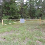 (4) The woods hold hunting clubs. I recall while in grad school in Baton Rouge reading the sportsmen ads for hunting leases in Mississippi. Well, here they are. This photo is the entrance to one. I saw entrances like this to a dozen “clubs.” I am guessing that there is an old trailer back in the woods that serves as the hunting cabin – just like in Field and Stream.
(5) Two people stopped their cars to talk to me about the article they say in today’s Hattiesburg American. One person gave me the newspaper clipping. Here is a link to the article.
Now go back to # (1) – the day seemed boring. I guess it wasn’t. This is a lot of fun.
Tags: Lamar County · Mississippi · Pearl River County
by Dwayne Phillips
Ah, Autumn. We went from mid-August to mid-November in 12 hours. Today, 55 to 65 degrees with high winds from the north – dry and cool. Wow, what a difference. I look forward to a few days of Fall weather.
I walked 17 miles today. I walked through Petal and Hattiesburg, Mississippi.
Petal is a town attached to the northern city limits of Hattiesburg. I couldn’t tell where Petal ended and Hattiesburg began. Route 11 is a four-lane divided highway with industry on both sides. It isn’t pretty (parts are downright ugly), but it is jobs.
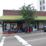
South Bound Bagel and Coffee Shop
Soon I was in downtown Hattiesburg. I like this downtown. They are working hard to “revitalize” it (sounds like a good government term).
We ate breakfast at the Southbound Bagel and Coffee shop (photo here). For the past month, I have been eating free breakfast at the motels. Bagels are common fare at these places. The motel bagels, however, only have a vague resemblance to the real thing. South Bound has the real thing AND good coffee. Great breakfast. The place is little, no one wears a uniform; they don’t even have two coffee mugs in the place that match. G R E A T place!
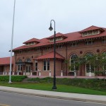
The Hattiesburg Train Station
Here is a photo of the train station. It is a working train station with Amtrak coming through. This place has been remodeled completely. Very nice.
Next is a photo of the Post Office. I put a copy of this on the Wikipedia page for
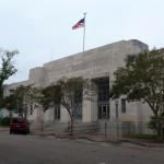
The Hattiesburg Post Office
Hattiesburg. Notice the carvings on the building to either side of the words. There are pictures of what looks like airplanes from the 1920s or 1930s. I looked around the building inside and out, but couldn’t find a date of construction.
And now we have a swan. This swan is about four feet tall. I saw half a dozen of these swans in the downtown area. I learned that these are part of some civic program to improve the appearance and morale of the city. There are 182 such swans around Hattiesburg. They are not all painted like this one. I doubt that any two are painted alike. I think that each business or such that hosted one was able to paint it any way they wished.
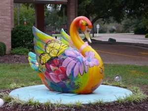
1 of 182 Swans
I have to write that I probably wouldn’t have bought 182 four-foot-tall swans to improve civic appearance and morale, but then again I am an engineer and a boring one at that.
It didn’t take long to walk through Hattiesburg. The city is spread East to West, so walking North to South means a quick passage. I walked through about seven miles of rural area after exiting the city. The traffic was surprisingly heavy. I expect to transit a couple of small towns tomorrow. The weather should remain cool and dry and W I N D Y.
And one more thing – I was interviewed by the Hattiesburg American newspaper. My nephew lives here and knows some people at the newspaper. I will look for an article and post a link if I have one. They were friendly, interested, and interesting people.
Tags: Forrest County · Lamar County · Mississippi
by Dwayne Phillips
Some break in the weather today – no rain. We had the next worst thing – heavy fog in the morning. Everything becomes wet, but slowly and surely, not quickly and surprisingly. The temperature ranged from 75 in the fog to 85 and cloudy. The sun didn’t come out on us while walking.
I walked 19 miles today. I walked through Ellisville, Moselle, and Eastabuchie. Don’t ask me how to pronounce the names of the latter two places. I don’t know.
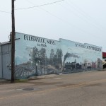
Wall Mural in Ellisville
Ellisville is a town. It has a downtown that looks pretty good. Here is a mural from one of the buildings. Several of the buildings in downtown have been repainted and remodeled. It is pretty and nice. Ellisville also has a Golden Mile to I-59, so it has plenty of those types of business as well (McDonald’s, Sonic, Pizza Hut, and so on).
Ellisville also has Jones County Junior College. My sister-in-law teaches nursing there. They have over 5,000 students – that is a lot of students for a junior college. I put a photo of what you see of the college from Route 11 on the Wikipedia page for the college.

The Howard Technology Park south of Ellisville
South of Ellisville is part of Howard Industries. I don’t know the history of Howard Industries, but it is tied closely to this part of Mississippi. Here is a photo of the Howard Technology Park. The photo isn’t too good as it was taken in the fog. This is a high-rise, glass office building. This isn’t supposed to be here. It looks like the building where I work in Herndon, Virginia, but it is out here in the middle of Jones County Mississippi. Someone needs to explain this one to me.
It is about 20 miles between Ellisville and Hattiesburg. There isn’t much in
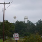
Twin Water Towers of Moselle
between. One place is Moselle. There isn’t any road signs that say you are there. A few houses cluster on Route 11 as do a few industrial businesses. I saw these two water towers to the east of Route 11. Twin water towers are unusual. I put this water towers photo on the Wikipedia page for Moselle.
Next is Eastabuchie. We ate a good lunch at a General Store there. I should have taken a photo, but wasn’t thinking at the time. I was too busy eating smoked (not grilled) chicken. Good stuff.
North of Hattiesburg is all industry that is fed by rail roads. There is a lot of oil and gas work in this area of Mississippi. Much of that industry is based here north of Hattiesburg.
Question: If you rearrange the letters in “cap and trade” can you spell “higher unemployment”? I don’t think so, but I fear that one will lead to the other – at least here.
The title of this blog comes from this photo. It is a large safety sign outside on of the industrial businesses north of Hattiesburg. Click to enlarge and read the top line of the sign.

Stupid Hurts
I LOVE THIS SIGN!
I know it is about safety, but I can think of all other sorts of places that it applies.
Tags: Forrest County · Jones County · Mississippi
by Dwayne Phillips
I walked 18 miles today. Yes, I am slowing as the week progresses. Perhaps I did too much on Monday and Tuesday (20 and 19.5 miles respectively). My excuse was the rain again this morning. I didn’t have the energy to trudge through miles in the rain. Instead, we sat around in Laurel for a couple of hours to let the rain pass. The afternoon had no rain, but about 200% humidity. I carry business cards in my shirt pocket. They are soaked at the end of almost every day. Last year we had frost by this time in Tennessee. Tomorrow should be in the high 80s. Gasp.
I walked through Sandersville, Laurel, and Pendorff, Mississippi.
Sandersville is a small town. It has a dozen businesses along Route 11. The good news is they are all open and active. I put a photo of the Sandersville post office on the Wikipedia page for the town.
Laurel is a city of about 20,000 people. Route 11 runs along the southern edge of the city. Laurel isn’t much to look at from Route 11. The north end of town is old houses that aren’t well maintained. The south end of town comprises several miles of similar homes and businesses. The good news is that the businesses are open and active. The bad news is…they just don’t look good. See, for example, some ugly concertina wire on a business.
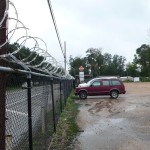
Concertina Wire (not) Decorating a Business in Laurel, Mississippi
We found a good coffee shop downtown a block off Route 11 near the train station. The name is Lee’s Coffee and Tea Shop. A great place to wait for the rain to stop.
The train station is an actual working train station with Amtrak passenger service. I put a photo of the train station on the Wikipedia page for Laurel.
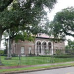
The Eastman, Gardiner and Company Building
Just a little south of the train station is this large building. It looks like a courthouse or something. It is the office of Eastman, Gardiner and Company. Some looking on the Internet taught me that this company at one time owned the entire city. They ran the railroads and all the lumber industry here. The company goes back into the 1800s. A really nice office building.
Pendorff is an area immediately south of Laurel. I couldn’t tell where Laurel stopped and Pendorff started. I also couldn’t tell how to spell Pendorff. The green sign naming the area had two fs on the end of the name. All the places that were Pendorf-this or Pendorf-that had one f on the end of the name. Confusing? It was to me.
And then there are the pick up trucks. I took this photo in the morning in Sandersville. I count 13 pickup trucks in this parking lot next to a coffee shop. I live in Reston, Virginia. There I could take a photo with 13 SUVs in a Starbucks parking lot. The pickup trucks actually seem to have more utility in the rural south than the SUVs have in suburban Virginia. Just a change of place and change of habit.
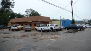
Pickup Trucks
Tags: Jones County · Mississippi
by Dwayne Phillips
No rain today, that was nice. Heavy fog in the morning at 68 degrees and gray overcast skies at 80 degrees in the afternoon. I thought it would be cooler here by now. It is supposed to be in the mid-80s tomorrow. You get damp when walking in the fog.
I walked 19.5 miles today (according to the iPhone GPS). That is a bit farther than I wanted, but I found a milestone to hit and walked all the way to it – probably a bad choice.
I was surprised today by the scarcity of homes on Route 11. For most of this walk, we would almost never be farther than a quarter mile from a home. Today, I went a couple of miles between homes of any kind. The terrain was up and down and there were lots of pine trees everywhere.
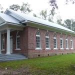
A Church in Barnett, Mississippi
We didn’t pass through any towns today. Route 11 comes within a couple miles of Heidelberg. That is spelled with an “e” not a “u” in the -burg or -berg part. Can someone tell me what the “e” means?
I did walk through Barnett, Mississippi. It was a green sign on the side of the road, and that was it.
Barnett did have this church building (left) next to its sign. There were no signs at the building indicating which church it was, and if you look closely you can see that there is a padlock on the front door. There is a cemetery out back. I saw a memorial plaque on the front of the building that read “1935.” I don’t know if that is the age of the building or merely the age of the plaque. What is unusual is that most rural church buildings of this size and style are made of wood. This one is of brick. A handsome building.
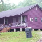
A Purple House
Next along the road was this purple house (to the right, as if I had to tell you which photo was of a p u r p l e house ;). I guess the owner likes the color. I hope the owner likes the color. I would go for a shade of brown myself.
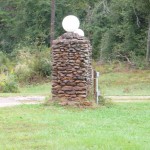
Where did the find these rocks?
Next was this stone lamp post. Folks, I haven’t seen many rocks in the fields around here. I haven’t seen natural rock in days. Where did they find all the rocks to build this post? There were three such posts here.
Then there was the Stafford Springs Restaurant. The sign to the right is a B I G sign. This used to be a restaurant and motel. I couldn’t tell how long it has been closed. My guess is 20 years, but not much longer than that.
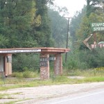
The Stafford Springs Restaurant
Finally, to the title of this post, this photo shows a turn off to nowhere. I saw a couple of dozen of these. Back in the Shenandoah Valley of Virginia I would see stairways to nowhere. Those were concrete stops leading up from Route 11 to a patch of trees and brush. At one time a home sat on that patch.
Look closely at the photo. You can see the darker asphalt leaving the light gray road-way. To the right in the center of the photo is an old, old concrete pipe. This was once a driveway leading to a home, barn, or pasture. It only leads to trees and brush now.
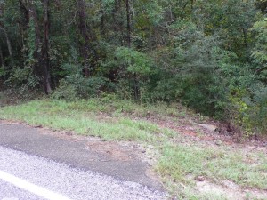
Turn Off to Nowhere
Time passes by each of us. Concrete outlives us. Sometimes it is concrete steps to nowhere; sometimes it is concrete pipes under driveways to nowhere.
Tags: Clarke County · Jasper County · Jones County · Mississippi
by Dwayne Phillips
A side story…
One day last week when the sun blazed most of the day and the temperatures reached into the 90s…
I was at the motel for the evening. I was walking down the hallway towards my room. In front of me was an old couple (almost as old as me ;). They were walking slowing and both with slight limps. The woman turned, noticed me, and started to move to the side with a, “Oh, I’m sorry. I didn’t know I was holding you up.”
“No problem,” I replied. “I’m not moving very fast myself.” That was true as I was tired, sore, and a little dehydrated.
Her answer was, “You must have been playing golf today.”
That was a pretty good guess as many men my age play golf for recreation. Some of us, however, walk a thousand miles in all kinds of weather for recreation. Just a different set of preferences. Perhaps I should take up golf. I may be missing something.
Tags: Uncategorized
by Dwayne Phillips
Today was a holiday, so the traffic was a little different and there were no school buses. It rained today – off and on all day. It was 65 degrees, but the precipitation was:
- drizzle
- heavy rain
- mist
- repeat six times
I was fortunate that I had a different logistics system today. Due to the big help, I walked 20 miles today. Walking 20 miles in the rain is not a good idea (let’s see how my feet are in the morning), but I had nothing else to do.
I walked through the little towns of Enterprise and Pachuta, Mississippi. There wasn’t much between and before them. This is all a rural area with lots of trees. There was a railroad track a hundred yards away from me, but I didn’t see much of it during the day. The trees were too thick.
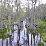
Swamp north of Enterprise, Mississippi
I did see some swamps now and then. Here is a photo. I think this would look nice on a sunny day. I like the way swamps look – from a distance, not from inside. This swamp was on the north side of Enterprise.
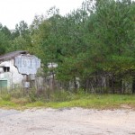
An old cafe and motel
Another unusual sight north of Enterprise was this old cafe and motel. To see the remnants of the motel you have to look closely in the trees and brush to the right of the two-story building.
I studied the sign in front of the building. I think it used to read “Aileen’s Court Cafe, air conditioned.” This is a neat old building, and I like how they used to build the motels and cafes together.
I didn’t take any photos of Enterprise. It was raining, I was tired, and it just didn’t work. Enterprise has a bank, a couple of gas stations, a diner, and a Dollar General store on Route 11. I think there was more of it off a quarter mile near the railroad tracks. There is a Wikipedia page for Enterprise with more information.
We ate lunch at the diner. It was good to come out of the rain. I had a pleasant conversation with a couple of men who had seen me walking on the road during the morning.
The town of Pachuta is smaller than Enterprise. It also has a bank, a public building (combination Town Hall, Library, and Fire Department), and six or eight empty buildings. I put a photo of the public building on the Wikipedia page of Pachuta.
Tags: Clarke County · Lauderdale County · Mississippi


