by Dwayne Phillips
I am happy to report that I have a new logistics routine. My older brother has joined me as a support driver. He drives me to the start point of the day, meets me for lunch, and picks me up at the end of the walking for the day. No more backtracking with my bicycle. I did the bicycle logistics from Chattanooga, Tennessee to Meridian, Mississippi. That is almost 300 miles.
Plus, do you know how hard it is to spell “Chattanooga,” “Tennessee,” and “Mississippi?” You have to remember where to put the double letters and where to put the single letters, like Chattanooga has one “n” and Tennessee has two “n”s. It is too confusing.
I don’t miss the bicycle.
Tags: Uncategorized
by Dwayne Phillips
The rain caught me today. Prior to today, I was able to watch the weather radar on the Internet and the iPhone, wait out lines of showers, and walk in the good weather. It didn’t work today.
I was on the road at 7AM – in the rain. I called it quits after five miles. Later the rain stopped. I went out on the road again, and the rain started. I called it quits after five miles. While sitting here in the afternoon entering this blog it is not raining. No, I will not try it again.
I did walk ten miles: five into and five out of Meridian, Mississippi. Meridian is a city of 40,000 people. It is the largest city on this half of the walk after Birmingham and Tuscaloosa, Alabama. Route 11 skirts the southern edge of Meridian, so I didn’t see much of the city. There is a bunch of frontage roads that parallel I-59. I don’t know who designed these roads. I don’t think anyone designed these roads. What a mess, around and around in circles.
Meridian has one of every major motel in America. Meridian has one of every major fast food chain in America. Yikes.
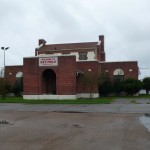
The Old Building at Key Field
Meridian has an aviation history. Here is a photo of the main “old” building at Key Field. This building pre-dates WWII. The field is named after the Key brothers who set an time aloft record in the 1930s that stood for decades. Then the two Key brothers served with distinction during WWII.
Meridian has an Air National Guard base at Key Field. Meridian also has a Naval Air Station.
I hope to pile up the miles starting Monday. My older brother (who once worked at Key Field as a mechanic) is going to do some support driving for me.
Tags: Lauderdale County · Mississippi
by Dwayne Phillips
It was hot today folks. 80 degrees at 6AM and 95 in the afternoon. During today’s walk, I drank four 20-ounce bottles of water, one 20-ounce bottle of Gatorade, one 20-ounce Welch’s Grape Soda (the number 2 best soft drink in the world), one 12-ounce Coke, and one cup of coffee.
I managed to walk 18 miles in the heat. That probably isn’t good for an old man like me, but whatever, there was road in front of me. Saving me was the time of year – the sun is low in the fall – and the tall pine trees along the road. I was in the shade about half of the day.
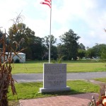
The Cuba Memorial
The last town in Alabama was Cuba. I like Cuba. Almost all the homes in the area were well kept. People here seem to like it here and want it to look nice. Pictured here is the Cuba memorial. If you click and enlarge the photo you may be able to read the inscription on the marble. Basically, this memorial is from the residents of Cuba saying thank you to those who settled here years ago. It is a thank you to their parents and grandparents. I have the sense that people here like it here. I feel real community pride that becomes action.
I put a photo of the Cuba Post Office on the Wikipedia page (yes, there is one for Cuba). I also put a photo of the Cuba Museum – yes, these people have built their own historical collection. It wasn’t open at the time of morning that I passed it. Yes, I think these people like the place where they live.
All you see of Cuba on Route 11 are a couple of gas stations, the memorial, and the museum. I like this place.
I walked into Mississippi. I really wanted a photo of me next to the “Welcome to Mississippi” sign, but there wasn’t such a sign. I knew I was in Mississippi because the pavement changed and I could see the “Welcome to Alabama” sign in the other direction. What a shame, I had such hopes of me and that sign.
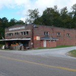
The Simmons-Wright Company
The first place in Mississippi was Kewanee. Nothing there but this store and a closed truck weigh station. I ventured into the store and found treasure. This place has been owned and operated by one family since 1884. The current manager has only been at it for three years. This is his retirement after 30 years working in logging. His great-grandparents opened this store.
This store is a museum. The architecture is fabulous. Notice that is appears to be a two-story building. The second story is a catwalk around the perimeter of the building. The ceiling for the first floor must be 30 feet high. Almost everything from the cash register to the coke machine (still working) is an antique. Photos of the family from the late 1800s are on the wall. Places like these are real treasures – living treasures.
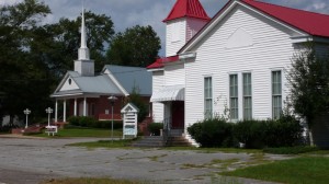
The next place was Toomsuba. There were a few homes on Route 11 and these two churches – one Baptist and one Presbyterian. The Presbyterian church was founded in 1836. That is pretty old for this area.
Up next is the big city of Meridian – a city of about 40,000 people.
Tags: Alabama · Lauderdale County · Mississippi · Sumter County
by Dwayne Phillips
Another 18 miles walked today. The temperature was 68 degrees in the morning with a low cloud cover. We ended with 88 degrees and mostly sunny. I am glad that I was able to start at 7AM and end before 3PM. After 3PM the heat coming off the pavement is much worse than that coming down from the sun. Plus, the sun is low in this sky this time of year making it difficult to see.
I walked through the towns of Livingston and Troy, Alabama. A note on the use of the term “town.” Boligee and Epes were towns, but nothing like Livingston and Troy. Today’s “towns” are the biggest I seen since Tuscaloosa. I Iike both Livingston and Troy – especially Livingston.
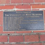
All the names of the University of West Alabama
The University of West Alabama is in Livingston. It has about 5,000 students. That is double the town’s regular population. This university started in 1835 as the Livingston Female Academy and Livingston Female Seminary. I found the plaque shown to the right giving the many different names this place has had since 1835. This is quite a heritage. Click on the photo to expand it and read the names.
Half the town is the university. The rest of the town is nice, pleasant, quite attractive to me. Route 11 is a four-lane road lined with mature trees and well-kept houses of all styles, shapes, and sizes. There is nothing like mature green trees to shade and cool you on a hot day. Ahh.
I like towns with universities. You go in a fast food place, a gas station, a grocery store, a little Chinese restaurant, and there they are – optimistic, energetic, a bit foolhardy, but with the whole world in front of them – students. It does something for me.
Livingston is the county seat of Sumter County. I put a photo of the courthouse on the Wikipedia page of Livingston.
Troy is a little smaller than Livingston. It is much smaller when you count the university in Livingston. I was surprised to find a two-block long downtown area. I was pleasantly surprised to see that about nine out of ten store fronts were occupied. I put a photo of the downtown on the Wikipedia page for Troy.
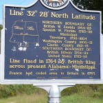
Historical Geographic Plaque North of York
A surprise was this historical marker on the side of the road just north of Troy. This marks 32 degrees 28 minutes north latitude. The plaque explains some history, but basically France “gave” all the land south of this parallel to England in 1763 – yes that is 14 years before America. You never know what you will see on the side of the road. You don’t see this on the Interstate. That is too bad.
One more photo for today. Early in the morning I was walking along Route 11 north of Livingston. I walked up a little rise, the trees lining the road thinned, and I saw this scene. I could see for miles – pastures, hills, trees, sky. The photo doesn’t do it justice. This is one of the big reasons why I am taking a walk – scenes like this. They do something for me.
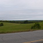
Pasture, Trees, Hills, Sky North of Livingston, Alabama
Tags: Alabama · Sumter County
by Dwayne Phillips
I awoke to the sound of thunderstorms (seems like a good title for a book or something). They were moving through the area. This delayed the start of walking today and also caused me to break the walk for an hour in mid-morning. The temperature was 65 degrees with the threatening skies this morning, but 80 degrees with not a cloud in the skies at the end of the day.
I walked through the towns of Boligee and Epes, Alabama. I walked 18 miles today. Given the late start and the distance, I am trying with all my might to complete this post before collapsing into bed.
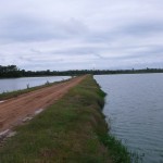
Two Catfish Ponds North of Boligee, Alabama
North of Boligee are catfish farms with catfish ponds. I don’t think I’ve ever actually seen catfish ponds before. I knew they farmed catfish is Mississippi, but I didn’t know they did so in Alabama. I must have seen two dozen catfish ponds today. The ponds are much bigger than I thought they would be. Here is a photo of a couple of them taken from between them.
There isn’t much left of Boligee. The railroad tracks run through the center of town, so my guess is that at one time farming and shipping produce by rail were big things in this little town. The saddest thing to see in a little town are concrete slabs with no building on them. I saw half a dozen of these in Boligee. There is a post office, and I put a photo of that on Boligee’s Wikipedia page.
A highlight of the town is the Boligee Cafe. This is run by Annie Lou. She is an elderly lady. The cafe burned to the ground a few years ago. Men in the community – catfish farmers, other farmers, railroad workers – came together and erected a new building for the cafe. They almost had to as there would be no place else for them to eat lunch. And they do eat lunch at this little place. The pickup trucks are parked on both sides of Route 11 at lunch time. Today’s special was Pork Chops, Creamed Potatoes, Black Eyed Peas, and Cornbread.
The pavement on Route 11 changed at Boligee. It went from great to terrible. North of town the road was paved smooth with shoulders. South of town, well, it was just bad. It hasn’t been paved in 30 or 40 years.
Look closely at this next photo. I was walking along talking and singing to the cows in this pasture. They were all looking at me. I uploaded this photo in full resolution, so you may have to click on it to see the faces of the cows. So if you ever want to be the center of attention, walk in the country, pass a pasture full of cows, and start talking to them. They will all pay attention to you. This could be used as a type of therapy for some of us.
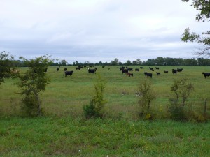
The Cows are All Looking at Me
There isn’t much of Epes – a gas station and a few churches. At least it doesn’t have empty concrete slabs like Boligee. Epes sits on the south bank of the Tenn-Tom Waterway. Here is a photo of the waterway and a railroad bridge crossing the water at Epes. Note the bluffs on the bank. These are about 30 feet high.
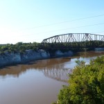
The Railroad Bridge Over the Tenn-Tom Waterway at Epes
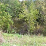
Swamp Between Boligee and Epes
And one more photo. Between Boligee and Epes is a swamp. Here America is a photo of a swamp. It has miles of vegetation growing in mud punctuated by water that is three to six-feet deep with no bottom.
Tags: Alabama · Greene County · Sumter County
by Dwayne Phillips
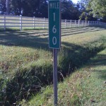 In Georgia and Alabama, there are mile markers along the side of Route 11. I don’t recall seeing these in Virginia and Tennessee. These mile markers are a blessing and a curse.
The blessing is that it is easier to keep track of my progress. I know how far I have walked each day. I don’t have to estimate based on Google Maps and the odometer. I just do a little subtraction. Another blessing is that they help me gauge the legs of my walk. Just enough, not too little, not too much.
The curse is I know how far I have walked each day. There are times when I feel like I have surely walked farther than the mile markers indicate. In the end, I can’t argue with the mile markers. Let’s see if Mississippi has mile markers.
Tags: Uncategorized
by Dwayne Phillips
Today I walked 16 miles through the fog and humidity. I went near the town of Knoxville (I think I did) and through the town of Eutaw, Alabama.
The weather was the story for most of the day. At 7:30AM I was in a heavy fog at 68 degrees. When in the fog, everything becomes damp on the outside. There is no escaping it. After walking a few miles, the inside of my shirt becomes wet as well. Nothing dries. Nothing dried all day as the fog lifted a little, but the overcast skies and high humidity remained. Oh well, I wash and so do my clothes.
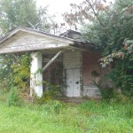 I think I walked near Knoxville. There was a green sign on Route 11 declaring “Knoxville.” I never saw anything else. I did see several places labeled “Knox this” and “Knox that.” Perhaps some of the original Knoxes are still here. Here is a photo of a closed gas station. Something about this style of old place attracts me. I have seen many of these.
And then there was this other closed gas station. I don’t know when it closed, but notice the price of the gas $1.09. When did gas cost that much? Anyone remember? If we can, we can date this place’s closing.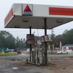
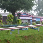 Next on the road was this house. It was hard to take a photo as the house is up above the road. I don’t know if this is something special, but it has a special paint scheme. Some sort of blue and pink. Why do people paint their houses this color?
And moving down the road, here is a Cadillac. A classic convertible. Can anyone identify the year, make, and model? I’ve never ridden in one of these, but would love to.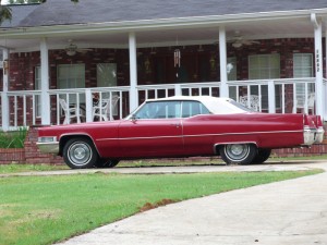
And then there is Eutaw, Alabama. I don’t read ahead on these towns. I like to be surprised and to learn when I walk into town. I was very surprised. This is an old town. Greene County was formed in 1819 – long before Alabama was a state. Eutaw is the county seat, so it is an 1819’er as well. In the center of town is the old town square. In the middle of that is the old courthouse shown here. It was built in 1869. Amazing.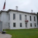
Now to the not so good news about Eutaw. Look close at the old courthouse. It needs to be fixed. It is vacant. They cut the grass in the town square, but that is about it.
The same not so good news holds for the rest of downtown. I put a photo of downtown on the Wikipedia page of Eutaw. About two-thirds of the store fronts are empty. It doesn’t look good.
The north side of Eutaw doesn’t look good either. Old, little houses falling down.
The rest of town is a different story. Beautiful homes of all sizes and ages on the Route 11 walk out of town. Several large, old churches as well. Really a nice, old town if you stay on the north (west) side. The town of 1,800 people has several dozen buildings on one national historic registry or another. It is quite impressive. It reminds me of the towns in the Shenandoah Valley of Virginia and the old towns of Tennessee.
Few people? If you don’t like the crowds of a city, buy a few acres and build a house in Greene County Alabama. There are 16 people per square mile in this county. That isn’t many. Tuscaloosa County, home of Tuscaloosa and lots of rural areas, has 124 people per square mile. It is a bit odd walking along the road mile after mile and not seeing a church, gas station, or anything. I just looked at Tangipahoa Parish Louisiana where my mother lives and where I went to high school. It has 127 people per square mile. Wow.
Tags: Alabama · Greene County
by Dwayne Phillips
I carry a little notebook and pencil with me while walking. Here is a photo (right) of them sitting next to a coffee cup for scale.
I use a notebook from Moleskine, but just about anything would work. I use a little pencil like those that golfers use to keep score. I found the pencil at a rest stop somewhere. I think it says The Virginia Lottery or something like that on it.
 The next photo (left) shows a couple of typical pages in the notebook. When I see something of interest or take a photo on the road, I jot a note. I also record times, weather information, mileage, odds and ends.
I find the notebook a necessity. At the end of most days I cannot remember what I saw or did at the start of the day. That is a combination of seeing and doing so many things and, yes, simple fatigue. I am too tired to remember.
I strongly recommend that people carry such a notebook and pencil or just 3×5 cards and pencil with them at all times. Then again, I am a writer and don’t have a great memory.
Tags: Uncategorized
by Dwayne Phillips
Today I walked 18 miles on an overcast and cool day. I left Tuscaloosa and walked through the towns of Fosters and Ralph, Alabama. It was 62 degrees and misty in the morning and 68 in the afternoon. The overcast skies made it perfect for walking – light sunburn risk. The gray skies didn’t make for good photos though.
I started the day at Stillman College in Tuscaloosa. Stillman began in 1876 to train black Presbyterian Ministers. It has been in Tuscaloosa its entire lifetime. A beautiful campus, it has about 1,500 students. Here is a photo of the library. One thing that is almost universal about colleges is that at 7:30 AM (when I took the photo) the campus is almost deserted. Same as LSU in 1980. Something else that is almost universal in colleges is the clocks are all wrong. Note the different time on the different faces of the clock. Same as LSU in 1980.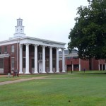
I continued walking on Route 11, and in ten miles I was out of town – way out of town. I like Tuscaloosa. It is a small city with three colleges. There is one of every national motel chain in town. There is one of every national store chain in town. There is one of every national restaurant chain in town. There is one of every national fast food chain in town. Shopping and dining are great, lots of variety. A suburbanites dream land.
Ten miles south on Route 11 and you are in a sparsely populated rural area. This is ten minutes from downtown and shopping and colleges and everything. It was a startling difference with no transition.
One nice thing was the first ten miles was all flat land. The last 15 miles entering Tuscaloosa were big hills – up and down and up and down. Flat land is much easier on the feet and the calves.
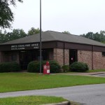
Fosters, Alabama Post Office
The first small town I walked through was Fosters. There is a Post Office (pictured here), a gas station, and an interstate exit on Route 11. The rest of the town is off on a side road.
The next small town was Ralph. I just love the name “Ralph, Alabama.” Ralph is not on Route 11, but on a side road named “The Ralph Loop.” I’m not making that up, there is this semi-circle road off the side of Route 11 called “The Ralph Loop.” I couldn’t resist. I never go off on the side roads to see towns, but I had to take “The Ralph Loop” (that should be the name of a book or a movie of something). I found a gas station, Bar-be-que place, fire station, and a U.S. Post Office – pictured here.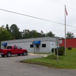
The shame is that neither Fosters nor Ralph have Wikipedia pages.
I ended the day just inside Greene County. I think every state has a Greene County.
Tags: Alabama · Greene County · Tuscaloosa County
by Dwayne Phillips
The first question people ask me when I tell them that I am walking from here to there is, “but how do you do that? Do you sleep on the side of the road? Do you …”
Here is the method I have used for the past two weeks (Chattanooga to Tuscaloosa). I am alone for this stretch. I have a van and a bicycle. I use a method that I learned years ago when reading A Walk in the Woods by Bill Bryson.
- Put the bicycle at Point A
- Drive down the road to Point B
- Walk from Point B to Point A
- Ride the bicycle from Point A to Point B
- Repeat
I use a variation of this scheme.
- Park the van at Point B
- Ride the bicycle back up the road to Point A
- Walk from Point A past the van to Point C
- Ride the bicycle back from Point C to the van at Point B
- Move on and repeat
The key here is in step 3. I walk with the bicycle, i.e. I push it along while I walk.
Given all of this, I usually traverse a piece of road three times. That sounds boring, but it would surprise you how you notice something different each time.
This all allows me to sleep in a motel each night. I am not “roughing it” on this walk.
Some people have told me that walking while pushing a bicycle is a terribly hard thing to do. It doesn’t bother me much. I am becoming quite skilled at it. If ever there was an Olympic event concerning walking and pushing a bicycle, I would be in the medal running. Maybe we could have a professional league of bicycle pushers who earn millions of dollars. Maybe not.
Walking while pushing a bicycle is a pain at times in traffic. This usually happens early in the morning when people are driving to work. It also happens in cities in shopping areas.
Another part of this scheme is the actual bicycle riding. When I walk 18 miles in a day, I also ride a bike 18 miles. An 18-mile bike ride is not a major bike ride in itself. I know bicyclists who do 100-mile rides each day. Combine that 18-mile ride with an 18-mile walk and you have a lot of exercise in a day.
Here is a photo of my bike. I bought then some dozen years ago. I guess it is a trail bike or something. It seems to work well enough. I have had three flat tires in two weeks.
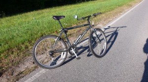
My Bicycle
Tags: Uncategorized


